


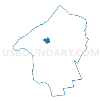
Union township voting district 1, Hunterdon County, New Jersey
About
Outline

Summary
| Unique Area Identifier | 619443 |
| Name | Union township voting district 1 |
| County | Hunterdon County |
| State | New Jersey |
| Area (square miles) | 2.59 |
| Land Area (square miles) | 2.57 |
| Water Area (square miles) | 0.01 |
| % of Land Area | 99.48 |
| % of Water Area | 0.52 |
| Latitude of the Internal Point | 40.61421410 |
| Longtitude of the Internal Point | -74.97438930 |
Maps

Graphs
Select a template below for downloading or customizing gragh for Union township voting district 1, Hunterdon County, New Jersey


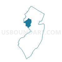
Neighbors
Neighoring Voting District (by Name) Neighboring Voting District on the Map
- Alexandria township voting district 4, Hunterdon County, NJ
- Union township voting district 2, Hunterdon County, NJ
- Union township voting district 4, Hunterdon County, NJ
Top 10 Neighboring County Subdivision (by Population) Neighboring County Subdivision on the Map
Top 10 Neighboring Elementary School District (by Population) Neighboring Elementary School District on the Map
Top 10 Neighboring Secondary School District (by Population) Neighboring Secondary School District on the Map
- North Hunterdon-Voorhees Regional School District, NJ (51,047)
- Delaware Valley Regional School District, NJ (16,680)